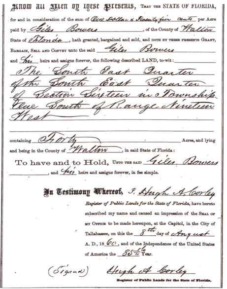
Lands Distributed by the State of Florida
Lands distributed by sources other than the BLM in 1 South 19 West
The Federal Government made it clear that said St. of Florida is admitted into the Union on the express condition that it shall never interfere with the primary disposal of the public lands lying within them, nor levy any tax on the same whilst remaining the property of the U.S. Portions of lands in the area were distributed by the BLM to private individuals by patents issued. The BLM entrusted the State of Florida with tracts of unencumbered lands that were sold to raise revenues for the state. The State and subsequently Walton County were entrusted with approximately 7269.09 acres of land within the township boundaries of 1 South 19 West. The State sold the lands in various ways, and private surveyors were hired with the sales that were not employees of the State. The survey work was sub contracted out to independent contractors and the field work done was not followed up on or confirmed by the State to check for accuracy, nor were copies made or filed into the public records of Florida. Thus the fires destroyed the only record of these transactions. In 1977, the State of Florida legislated Statute 177.502 as the Legislature finds and declares that it is the responsibility of the state, and in the public interest, to provide a means for the identification, restoration, and preservation of the controlling corner monuments established during the original cadastral surveys, to which the vast majority of titles to lands in Florida are related and which they are dependent. All such monuments and evidence pertaining to the original government surveys are resurveys are recognized as historical and economic resources of the state and, as such, are vitally important to the orderly planning, management, use, conservation, and public enjoyment of Florida’s natural resources. In order to implement this policy, the department shall assume the responsibility for conducting a program of the identification, restoration, and preservation of such monuments. The State of Florida created a program called Labins in an attempt to comply with F.S. 177.502, where certification of section corners are to be recorded. However, once again the State relies on the work of private surveyors to provide corner certification to Labins, and does not verify the accuracy of the corner certification. This is not a remedy to the problem, and only supports faulty survey work further by making the corner certifications public, so other surveyors can reference the “certified” corner. Most corner certifications filed with Labins reference living trees that are much too young to be authentic BLM witness trees, and no noted attempt is made at archeological excavation for the remains of root masses on most to verify a true corner. Each section corner has 4 witness trees listed in the BLM field notes. If the tree is harvested, the root mass below ground can be excavated, similar to a fossil dig. Discolorations, smears, chunks of debris, wood, etc.below the surface is checked for potential accuracy in relation to the monument under consideration. An ideal scenario is to find evidence at 4 of 4 locations identified with the Corner location under consideration. We have one witness location at the ACC monument that is too young to comply with the field notes, according to the results of radio carbon dating on the sample taken.
One glaring example of the problem with allowing private surveyors to certify corners is a case where a surveyor was unable to find existing witness tress in the area of a concrete monument, locally used by some landowners and ignored by others. An archeological dig was made at 3 referenced witness tree locations, and only one hole dug had evidence of a tree. The surveyor determined that the concrete monument was a true BLM corner and it has been certified. In the meantime, a sample of the tree evidence was sent to a lab to be radio carbon dated for age. The results came back that the tree time frame was about 1900, which made it too young to be a BLM witness tree. There was no other tree evidence found in the area of the corner. There is monumentation over 300’ to the south that appears to be placed by the USGS as a location for the section corner. This monumentation is ignored by surveyors as it is too far and therefore “discounted.” Discounting lightwoods stakes is also practiced in the area, which was the monumentation used by the BLM.
It would appear that not a single section corner within the entire State has been verified or restored by the State, as of yet.
Twenty of thirty six sections within 1 South 19 West were entrusted by the BLM to the State of Florida for public disposal for a total of about 7269.09 acres and are listed as follows:
All of Section 1 @ 640 acres
All of Section 3 @ 640 acres
All of Section 5 except the w ½ of the NW ¼ @ 560 acres
Section 6 – E ½ of the NE ¼ @ 80 acres
All of Section 7 except the s ½ of the SE ¼ @ 560 acres
All of Section 9 except the ne ½ of the SE ¼ and the se ¼ of the SW ¼ @ 560 acres
Section 10 – SE ¼ @ 160 acres
All of Section 11 except the s ½ of the NE ¼ @ 560 acres
Section 15 – the w ½ of the NW ¼ @ 80 acres
All of Section 16 @ 640 acres
Section 18 - the e ½ of the NW ¼ , the nw ¼ of the NW ¼ , the nw ¼ of the SE ¼ , the ne ¼ of the SW ¼ @ 200 acres
Section 19 – the w ½ of the SE ¼ , the e ½ of the SW ¼ @ 160 acres
Section 22 – the NW ¼, the w ½ of the SW ¼ @ 157 acres
Section 25 – the w ½ of the SW ¼ @ 80 acres
All of Section 26 except the NE ¼ and the e ½ of the NW ¼ @ 400 acres
Section 27 – the SE ¼, the w ½ of the SW ¼ @ 163 acres
All of Section 31 @ 117 acres
Section 33 – the SE ¼, the SW ¼ @ 322.50 acres
All of Section 34 @ 549.59 acres
All of Section 35 @ 640 acres