Walton Counties Management
- Walton County was formed on Dec. 29th, 1824
- Alaqua was the location of the first Walton County Courthouse
- in 1830 the Courthouse at Alaqua burned
- the Courthouse was moved to Eucheeanna in 1831, and in 1885 it burned
- in 1886 the Courthouse was opened at DeFuniak Springs
The Walton County Courthouse fires represent a setback to the Public Record and includes
-a loss of original documents that cannot be replaced;
-some administrative confusion results each time inside the courthouse as well;
-and some confusion results about property ownership out in the field but only because of the loss of the documents.
It is rightly said that “where there is confusion there is profit to be made”. So some things may have happened on paper because some people took advantage of this situation.
But clearly had the Walton County Surveyor’s Office been on the job the original monuments in the field would not have moved or been moved or destroyed as a result of a Courthouse fire
The public record is clear that there was an Office so titled. Yet today, the Clerk of Walton County cannot find these public records.
We cannot find out when this Office was first opened.
We cannot find out all of the names of the persons who were so appointed, hired or the pay they received for service in this Public Office.
We cannot review the documents they held or the work product that they produced.
We cannot discover when or why this Public Office was closed.
It is clear from the facts we have learned that part of the duty of any County Surveyor would be to maintain the monumented Township Grid, the monumented Section Grid within each Township, and the locations of the borders of the County at large - at very least.
It would make since to have this office confirm deeds before they are recorded into the public record, and assessed for Tax to confirm that the land “fits” into the Grid correctly.
Again, its that process known as “Checks and Balances”.
We cannot know for sure what was or was not done because there are no public records of that office in this County of Government Townships.
|
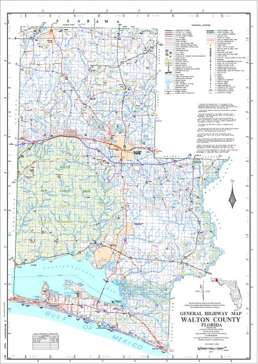
General Highway Map of Walton County Florida
published in Nov. of 2006 by the State of Florida’s D.O.T.
The reference to “General Land Office (GLO) Plats and inventory surveys” is connected to the Federal TRS grids on file with the Federal agency know as the Bureau of Land Management (BLM.) The General Highway Map is based on the U.S. Geological Survey (USGS) which is also a Federal agency and data source directly connected to the BLM / GLO established plats. The USGS published it’s quadrangle of Freeport in 1970. 
|
These surveys, along with the field notes, and the “Plat” or drawing of each survey, are archived into the public record of the United States, and on file with each State where the Federal GLO survey was made and most Counties have their copies on file in their public record.
The Federal survey of this Nations “Public Lands” was an extraordinary amount of work and it is sometimes hard to imagine just how intelligent and hardworking Americans are.
You might ask, is this true for all States, and the answer is no. The original thirteen states were not surveyed under the rectangular survey system. However, the majority of States were and Florida certainly is a “Public Lands” State. [If you do not live in Florida you can go on line and search the topic “Public Land States” and learn more about your State.]
The General Highway Map we looked at is based on a collection of 43 separate Federal Township surveys, all put together by the USGS and published in segments called a “quadrangle”. The General Highway Map is up-graded each time it is published with new roads and other details, but the base data stays the same. In fact it is very common for the USGS “quads” to be used as a base in this way because the USGS was required to use the original Federal surveys as the foundation for each “quad” they publish, and they are held to a low margin for error. This means they were and are required to be as accurate as the technology would allow in 1970 - 76.
