The SE 1/4 of Section 15
THE SE ¼ OF SECTION 15 The bottom 10 acres of the SE ¼ of 15 moves to the top of NE ¼ of SECTION 22. (need to finish research on the 4 acres)
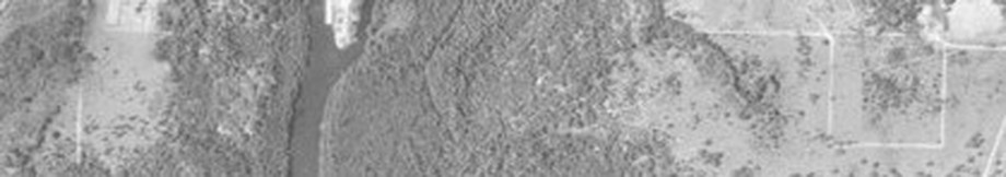
The original 160 acre patent to the SE ¼ of Section 15 is issued to Jason Mathews. Mathews conveys 157 acres to Lewis Jackson 7 years later (2). Jackson sells 156 acres, 15 acres to Rutan and 141 to McCaskill (3,4) Daniel Jackson buys and conveys forward 4 acres from McCaskill (5) and still has 10 additional acres is his and his heirs’ possession until 1974 (17, 18,19, 20) The 10 acres is conveyed and described as located at the top of the NE ¼ of Section 22, however Jackson never purchased land in Section 22. It would appear that Jackson fell into a gray area by 10 acres from a northward movement and relocation of the section line by the State of Florida and Walton County. This is the first direct link through public records that ties to an original patent holder and substantiates the north migration of section lines within the township. This prompted us to look at potential discrepancies at other corners, and we found them everywhere.The 10 acre tract is identified on the right side of the 1956 aerial photo as a square below a line on either side of the square. The bottom line of the square matches the proximity of the original location of the Section line on the TRS grid. The line on either side of the top of the square represents the current location of the Section line and is too far north when compared to the TRS grid. The same confusion of the Section line location can be seen on the opposite side of the creek - left side of the photo.
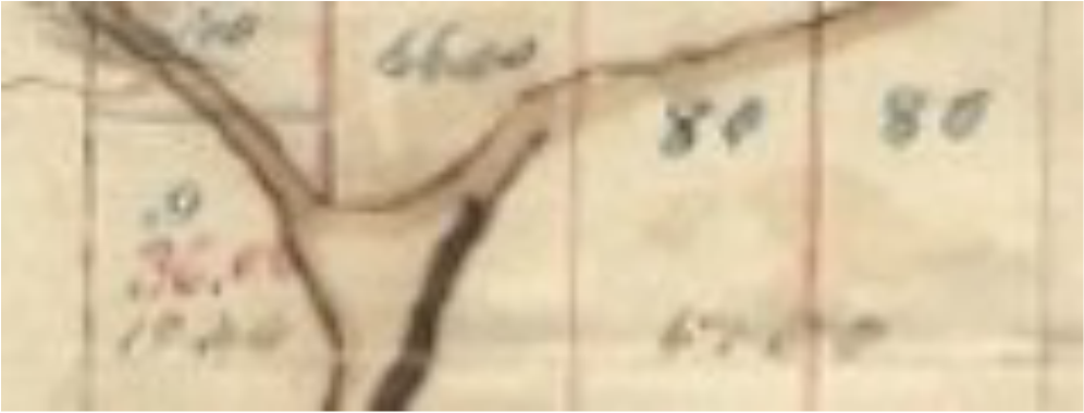
The Section line is originally shown on the TRS grid well below the junction of the 2 creeks. The image below shows the (faint) line with measurements noted just above the line.
The original 160 acre patent to the SE ¼ of Section 15 is issued to Jason Mathews. Mathews conveys 157 acres to Lewis Jackson 7 years later (2). Jackson sells 156 acres, 15 acres to Rutan and 141 to McCaskill (3,4) Daniel Jackson buys and conveys forward 4 acres from McCaskill (5) and still has 10 additional acres is his and his heirs’ possession until 1974 (17, 18,19, 20) The 10 acres is conveyed and described as located at the top of the NE ¼ of Section 22, however Jackson never purchased land in Section 22. It would appear that Jackson fell into a gray area by 10 acres from a northward movement and relocation of the section line by the State of Florida and Walton County. This is the first direct link through public records that ties to an original patent holder and substantiates the north migration of section lines within the township. This prompted us to look at potential discrepancies at other corners, and we found them everywhere.The 10 acre tract is identified on the right side of the 1956 aerial photo as a square below a line on either side of the square. The bottom line of the square matches the proximity of the original location of the Section line on the TRS grid. The line on either side of the top of the square represents the current location of the Section line and is too far north when compared to the TRS grid. The same confusion of the Section line location can be seen on the opposite side of the creek - left side of the photo.
The Section line is originally shown on the TRS grid well below the junction of the 2 creeks. The image below shows the (faint) line with measurements noted just above the line.
The land conveyed to Rutan as 15 acres identified by Lewis Jackson eventually becomes 30 acres as the chain of title is followed. This discrepancy further supports the northern migration of the section line and corner location.
Land sold to Rutan
Need to finish research
Back to the Mojo Report
- Deed Bk 33 pg 293 1882 Patent to Jason Mathews SE ¼ of 15 160 acres
- Deed bk 31 pg 401 1889 Mathews to Jackson SE ¼ of 15 for about 157 acres`
- Deed bk 6 pg 348 1892 Jackson to Rutan All that portion of Se ¼ of 15 west of Lafayette creek commencing at corner of post in center of section then east to Fafayette creek thence down the run of creek to land line dividing the SE and SW ¼ of Sec. 15, thence north to starting point embracing 15 acres more or less.
- Deed bk 7 pg 131 1893 Jackson to McCaskill SE ¼ of sec. 15 containing 156 acres less 15 acres on west side of Lafayette creek on right hand side of public road which lead to Lafayette bridge – same being sold to Rutan (bk 6 pg 348)
- Deed bk. 9 pg. 485 1900 McCaskill to Daniel Jackson – 4 acres of what is known as the J. Lewis Jackson place described as follows: Beginning at the SE corner ot SE ¼ of SE ¼ of section 15, and running north 840 feet along the section line dividing 14 and 15, thence west 210 feet then south 840 feet to section line dividing sections 15 and 22, thence along section line east to POB
- Deed Bk. 20 pg 321 1904 McCaskill to McCaskill – all that part south of LaFayette Creek in SE ¼ of 15 except 4 acres in SE corner sold to Dan Jackson 126 Acres
- Deed Bk 25 pg 395 1904 McCaskill to Stanley – that part or parcel of land lying in the SE ¼ of Sec. 15 beginning at a point 10’ south of LaFayette bridge where it now stands thence along creek 140 yards thence south 70 yards thence NE on a line parallel with creek 140 yards thence NW 70 yards to POB about 2 acres
- Deed bk 25 pg 55 1907 McCaskill to McCaskill – the SE ¼ of sec 15 less 30 acres sold to Rutan by Lewis Jackson as records will show, 4 acres sold to Dan Jackson by REL McCaskill as shown by record of deeds, and 2 acres sold to Joe Garrett by Lewis McCaskill as shown by record
- Deed bk 33 page 251 1907 McCaskill to McCaskill Inv. Same desc. As bk 25 pg 55
- Deed bk 40 pg 155 1914 McCaskill to Morris & Stanley Same desc. as bk 25 pg 395
- Deed bk 59 pg 98 1922 Ida Jackson to J.P. Ivey Auto Co. same desc. as bk. 9 pg 485
- Deed bk 66 pg 252 1926 McCullough to Kirkland Begin se c of se ¼ of se ¼ run n 840’ on 3 deg w then w 210’ on 3 deg s s 840’ on 3 deg e and e 210 on 3 deg n to POB for 4 acres
- Deed bk 51 pg 555 1928 McCaskill to George Wilkie / Bayview Tar All that part of the E ½ of the SE ¼ of Sec. 15 that lies south of Lafayette creek except bk 9 pg 485 and bk 25 pg 395 exceptions containing 6 acres
- Deed bk 69 pg 351 McCaskill to McCaskill Investment 14 acres lying east of Lafayette creek in the SE ½ less a tract beginning at the SE corner of the SE ¼ run N 840’ W 210’ S 840’ and E 21 to POB
- Deed bk 70 pg 97 1929 Bayview Tar / Z.D. Adair to George Wilkie same desc. as bk 51 pg 555
- Deed bk 82 pg 186 1938 Ivey to McCullough 210’ e and w by 840’ n and s at se c of se ¼ of sec 15 for 4 acres
- Deed bk 82 pg 310 1938
- Deed bk 82 pg 451 1938 Ivey to McCullough 210’ e and w by 840’ n and s at se c of se ¼ of sec 15 for 4 acres
- Deed Bk 82 pg310 Casey 1938 ½ Interest in E ½ of SE ¼ exc. 2 parcels totaling 6 acres in Sec. 15 (64 acres)
- OR bk 78 pg 615 1974 – Laurice and Richard Hunter to Diocese of St. Augustine
- OR bk 78 1974 pages 616, 618, 620, 622, 624, 626, 628, 630 certification of heirs of Daniel and Ida Jackson
- OR bk 78 pages 615,617, 619, 621, 623, 625, 627, 629 Deeds from heirs of Daniel Jackson to Paul Tanner of the Diocese of St. Augustine with description as follows: Commencing at the NE corner of Sec. 22 run south 00 deg. 14 min. 35 sec. East a distance of 666.33 feet thence run north 89 deg. 17 min. 15 sec. west a distance of 665.02 feet thence run north 00 deg 13 min 24 sec east a distance of 665.75 feet thence run south 89 deg 20 min 00 sec east 659.57 feet to point of beginning
- OR bk 78 pg 631 1974 Affidavit from Mollie Taylor as neighbor of Daniel and Ida Jackson
- OR bk 443 1975 Paul Tanner of the Diocese of St. Augustine to Paul Tanner as Bishop of St. Augustine same desc. as deeds in OR 78
- OR bk 2680 pg 64 2005 Easement from Diocese to Freeport Venture Partners same desc as deeds in OR bk 78
Land sold to Rutan
- Deed bk 3 pg 680 1872
- Deed bk 3 pg 678 1882
- Deed bk 5 pg 671
- Deed bk 6 pg 348 1892 Jackson to Rutan All that portion of Se ¼ of 15 west of Lafayette creek commencing at corner of post in center of section then east to Fafayette creek thence down the run of creek to land line dividing the SE and SW ¼ of Sec. 15, thence north to starting point embracing 15 acres more or less.
- Deed bk 6 pg 404
- Deed bk 2 pg 87 1880 1 acre as part of the NE ¼ of the SW ¼ of Sec. 15
- Deed bk 56 pg 124 1921
Need to finish research
Back to the Mojo Report
